Muslim Brotherhood waits in the wings - Globes: "The Egyptian revolution, which took so many in the West and in Israel in particular by surprise, was mainly motivated by the demand of the masses for economic justice. This transcended calls for freedom of expression, the right to organize politically, and relief from the rampant repression of the establishment including Mubarak, his family and cronies, the army and the ruling party.
Above and beyond the Tunisia effect, which certainly influenced the timing of the Egyptian revolution, western commentators have ignored Egypt's long tradition of protest."
Thursday, July 28, 2011
Israeli-occupied territories - Wikipedia, the free encyclopedia
Israeli-occupied territories - Wikipedia, the free encyclopedia: "he Israeli-occupied territories are the territories which have been designated as occupied territory by the United Nations and many other international organizations, governments and others to refer to the territory occupied by Israel from Egypt, Jordan, and Syria after the Six-Day War of 1967.

They consist of the West Bank, the Gaza Strip and much of the Golan Heights and, until 1982, the Sinai Peninsula. The West Bank and Gaza Strip are also referred to as the Palestinian territories or Occupied Palestinian Territory. The Palestinian Authority, the EU,[1] and the UN Security Council[2] consider East Jerusalem to be part of the West Bank, a position disputed by Israel. Israel has annexed East Jerusalem by the Jerusalem Law."

They consist of the West Bank, the Gaza Strip and much of the Golan Heights and, until 1982, the Sinai Peninsula. The West Bank and Gaza Strip are also referred to as the Palestinian territories or Occupied Palestinian Territory. The Palestinian Authority, the EU,[1] and the UN Security Council[2] consider East Jerusalem to be part of the West Bank, a position disputed by Israel. Israel has annexed East Jerusalem by the Jerusalem Law."
This Ongoing War: A Blog: 21-Jul-11: So who's winning in the war against the terrorists?
This Ongoing War: A Blog: 21-Jul-11: So who's winning in the war against the terrorists?: "Keren Malki, the Malki Foundation, is a memorial to the life of Malki Roth, our daughter, murdered at the age of 15 in a terrorist massacre in the centre of Jerusalem executed by terrorists in the service of Hamas. Beyond its function as a remembrance of a life lost, Keren Malki has provided and continues daily to provide tangible, concrete, invaluable support to more than two thousand Israeli families of every background - Christian, Moslem, Jewish, Druze and others - caring at home for a seriously disabled child."
This Ongoing War: A Blog: 21-Jul-11: So who's winning in the war against the terrorists?
This Ongoing War: A Blog: 21-Jul-11: So who's winning in the war against the terrorists?: "he DHS document refers to the 2010 case where a U.S. citizen, arrested in Yemen during a round-up of suspected al Qaeda members, was found to have worked for multiple contractors 'performing non-sensitive maintenance at five different U.S. nuclear power plants from 2002 to 2008' [Source]
Among the materials recovered after the operation that killed Osama bin Laden in May, US officials found evidence bin Laden sought to repeat the carnage of the Sept. 11, 2001 terror attacks on or around its ten year anniversary."
Among the materials recovered after the operation that killed Osama bin Laden in May, US officials found evidence bin Laden sought to repeat the carnage of the Sept. 11, 2001 terror attacks on or around its ten year anniversary."
Israeli–Palestinian conflict - Wikipedia, the free encyclopedia
Israeli–Palestinian conflict - Wikipedia, the free encyclopedia: "The violence resulting from the conflict has prompted international actions, as well as other security and human rights concerns, both within and between both sides, and internationally. In addition, the violence has curbed expansion of tourism in the region, which is full of historic and religious sites that many people would like to visit.
Many attempts have been made to broker a two-state solution, involving the creation of an independent Palestinian state alongside an independent Jewish state or next to the State of Israel (after Israel's establishment in 1948). As recently as 2007, a majority of both Israelis and Palestinians, according to a number of polls, prefer the two-state solution over any other solution as a means of resolving the conflict.[4] Moreover, a considerable majority of the Jewish public sees the Palestinians' demand for an independent state as just, and thinks Israel can agree to the establishment of such a state.[5] A majority of Palestinians and Israelis view the West Bank and Gaza Strip as an acceptable location of the hypothetical Palestinian state in a two-state solution.[6] However, there are significant areas of disagreement over the shape of any final agreement and also regarding the level of credibility each side sees in the other in upholding basic commitments.[7]"
Many attempts have been made to broker a two-state solution, involving the creation of an independent Palestinian state alongside an independent Jewish state or next to the State of Israel (after Israel's establishment in 1948). As recently as 2007, a majority of both Israelis and Palestinians, according to a number of polls, prefer the two-state solution over any other solution as a means of resolving the conflict.[4] Moreover, a considerable majority of the Jewish public sees the Palestinians' demand for an independent state as just, and thinks Israel can agree to the establishment of such a state.[5] A majority of Palestinians and Israelis view the West Bank and Gaza Strip as an acceptable location of the hypothetical Palestinian state in a two-state solution.[6] However, there are significant areas of disagreement over the shape of any final agreement and also regarding the level of credibility each side sees in the other in upholding basic commitments.[7]"
Kedumim - Wikipedia, the free encyclopedia
Kedumim - Wikipedia, the free encyclopedia: "Bnei Chayil
Yeshivat Bnei Chayil Shomron (Hebrew: ישיבת בני חיל שומרון is a high school yeshiva established in 1998[1] in order to provide an orthodox Jewish education for boys with ADD and ADHD. It is considered a unique facility in central Israel not limited to local students. Students in grades seven through twelve are divided into classes which are limited to a maximum of fifteen boys. The school in Kedumim was originally a branch of a Jerusalem school of the same name founded by Dr. Stuart Chesner.
[edit]Industry
While many residents work outside the village, many are employed locally in education as well as several agricultural enterprises working with greenhouses and orchards. The Bar-On Industrial Park on 1200 dunams (1.2 km²) of land is within the municipal boundaries of Kedumim.
Perhaps the most famous local company is Kedumim (3000) Construction Company which mainly deals with building in the West Bank/Judea and Samaria."
Giv'at Ze'ev - Wikipedia, the free encyclopedia
Giv'at Ze'ev - Wikipedia, the free encyclopedia: "iv'at Ze'ev is located on the 'Israel' side of the security fence. The town is patrolled by Mishmeret Ha'gvul and a local security force, and is secured by a security fence. Plans are underway to set a guard post near the entrance to route 443 (currently, the road is closed off by a security fence).
Giv'at Ze'ev is one of five settlement 'blocs' that '[m]ost Israelis believe [] should become part of Israel when final borders are drawn'[4] and 'both Prime Minister Sharon in 2005 and Prime Minister Benjamin Neyantahu in 2010 have repeatedly said the large settlement blocs will “remain in our hands.”'[5]
[edit]"
Giv'at Ze'ev - Wikipedia, the free encyclopedia
Giv'at Ze'ev - Wikipedia, the free encyclopedia: "Giv'at Ze'ev is the center of the Karlin-Stolin Hasidim and one of the town's most notable residents is the Stoliner Rebbe Boruch Yaakov Meir Shochet.
On March 9, 2008, Prime Minister Ehud Olmert approved the construction of 750 new homes in Giv'at Ze'ev under the Agan Ha'ayalot project. This approval stands in contrast to Olmert's policy of freezing new permits for expansion within existing settlements. Olmert argued that the project was first approved in 1999, but stopped in 2000, as a result of the Second Intifada. The approval was criticized by the Palestinian Authority, US Secretary of State Condoleezza Rice, and the European Union. On the political right, the Shas party took credit for pressuring Olmert to approve the project.[3]"
On March 9, 2008, Prime Minister Ehud Olmert approved the construction of 750 new homes in Giv'at Ze'ev under the Agan Ha'ayalot project. This approval stands in contrast to Olmert's policy of freezing new permits for expansion within existing settlements. Olmert argued that the project was first approved in 1999, but stopped in 2000, as a result of the Second Intifada. The approval was criticized by the Palestinian Authority, US Secretary of State Condoleezza Rice, and the European Union. On the political right, the Shas party took credit for pressuring Olmert to approve the project.[3]"
Har Hebron Regional Council - Wikipedia, the free encyclopedia
Har Hebron Regional Council - Wikipedia, the free encyclopedia: "Israeli Regional Council in the southern Judean Hills are of Mount Hebron in the southern part of the West Bank, administering settlements in the Hebron region, as well as others nearby. The headquarters are located adjacent to Otniel. Founded in 1983, the first settlement was Beit Yatir.
The current 'mayor' of the Council is Tzviki Bar Chai. About 5000 Israelis live in the council's municipal territory, most of which are not adherents of Orthodox Judaism.
While the local council of Kiryat Arba is physically located within the territory of the Har Hebron Regional Council, it is an independent local council.
Only three of the settlements, Eshkolot, Sansana, and Mazadot Yehuda, all on the southern edge of the West Bank, are on the Israeli side of the West Bank Barrier.[1]
[edit]List of settlements
This regional council provides various municipal services for the following villages within its territory:
Adora
Abigail
Beit Hagai
Beit Yatir
Carmel
Eshkolot
Livne (also known as Shani)
Ma'ale Hever
Ma'on
Mitzpe Asa'el
Negohot
Otniel
Sansana
Shim'a
Susia
Telem
Teneh Omarim"
Gush Etzion Regional Council - Wikipedia, the free encyclopedia
Gush Etzion Regional Council - Wikipedia, the free encyclopedia: "List of settlements
This regional council provides various municipal services for the following Israeli settlements within its territory:
Historic Gush Etzion:
Alon Shvut
Bat Ayin
Carmei Tzur
Gvaot
Elazar
Har Gilo
Kfar Etzion (kibbutz)
Migdal Oz (kibbutz)
Neve Daniel
Rosh Tzurim (kibbutz)
Judean Mountains:
Ibei Hanachal
Kedar
Kfar Eldad
Ma'ale Amos
Ma'ale Rehav'am
Metzad
Nokdim (El David)
Pnei Kedem
Tekoa
All of the settlements in the historic Gush Etzion area are on the Israeli side of the West Bank Barrier, except for Carmei Tzur. None of the settlements in the Judean Mountains area are, except for Kedar which is located far north of the others very close to Maale Adummim and is within the eastern Jerusalem section of the barrier."
Modi'in Illit - Wikipedia, the free encyclopedia
Modi'in Illit - Wikipedia, the free encyclopedia: "Located in the foothills of the Judean Mountains 286 meters (938 feet) above sea level, Modi'in Illit has mild winters and hot, dry summers with temperatures averaging 30 °C (86 °F) during the day. Modi'in Illit's immediate neighbors are moshav Matityahu and Hashmonaim.
Kiryat Sefer, the largest neighborhood, was established in 1994. In keeping with its name, 'Book Town', each of Kiryat Sefer's streets is named after a landmark sefer (book) written by Gedolei Yisrael. These include: Chofetz Chaim, Noda BiYehuda, Meshech Chochma, Avnei Nezer and Sdei Chemed. The second-largest"
Kiryat Sefer, the largest neighborhood, was established in 1994. In keeping with its name, 'Book Town', each of Kiryat Sefer's streets is named after a landmark sefer (book) written by Gedolei Yisrael. These include: Chofetz Chaim, Noda BiYehuda, Meshech Chochma, Avnei Nezer and Sdei Chemed. The second-largest"
Israeli–Palestinian conflict - Wikipedia, the free encyclopedia
Israeli–Palestinian conflict - Wikipedia, the free encyclopedia: "The Israeli–Palestinian conflict is the ongoing conflict between Israelis and Palestinians.[1] The conflict is wide-ranging, and the term is also used in reference to the earlier phases of the same conflict, between Jewish and Zionist yishuv and the Arab population living in Palestine under Ottoman or British rule. It forms part of the wider Arab–Israeli conflict. The remaining key issues are: mutual recognition, borders, security, water rights, control of Jerusalem, Israeli settlements,[2] Palestinian freedom of movement[3] and legalities concerning refugees."
Ma'ale Adumim - Wikipedia, the free encyclopedia
Ma'ale Adumim - Wikipedia, the free encyclopedia: "Land ownership
Peace Now, an Israeli NGO, initially claimed that 86.4% of Ma'ale Adumim was privately owned Palestinian land, basing the figure on data leaked from a government report.[12][13]
After Peace Now petitioned the Israeli courts to have the official data released, the group revised the figure to 0.5%.[13] Palestinians claim lands from the villages of Abu Dis, Al Izriyyeh, Al Issawiyyeh, Al Tur and Anata were expropriated for building in Ma'aleh Adumim.[14] Under Islamic land law, the land in question was categorized as arazi mewat, or 'dead lands.'"
Editors Note: There is absolutely no doubt that the information which exists on such matters, exists in great abundance. Additionally incomplete, or manipulated data must also play a huge part in these matters.
Conclusion For Today:
Statistics don't lie, people do.
Aharon Moshe Sanders, July, 28 2011- 1:55pm
The American mindset requires simplicity. The thing that is appreciated perhaps more so in this country than in others. Is a predisposition to favoring a particular side of given cause, issue or debate. The US political system itself for simplicity and convience's sake gets reduced to two major perspectives that are at odds with each other on most issues.
Adherents to a given cause are not very likely to change their belief system. Therefore media will often simply play up to the predictable effects that the selective reporting on particular issues that these issues will have on their target audience. Filtering through piles of data for truth becomes a nearly impossible task.
Therefore it will often occur in this country that people often end up believing the lies, and disregarding the truth. Often the facts behind the lies are based on some small aspect or insignificant technicality regarding an extremely narrow overly literal interpretation of law.
The effect of statistics for example is very often utilized to persuade those who are believers in facts and figures. However more sophisticated and educated citizens understand that while statistics per se, "do not lie", it is the selective usage of such stats that allows media manipulators to draw an incorrect conclusion.
Statistics don't lie, people do.
Aharon Moshe Sanders, July, 28 2011- 1:55pm
Selected Wikipedia.org Explanations: Sumaria & Judea
The editor, publisher, author of this blog is really more concerned with facts on the ground then any sort of theoretical approach from a purely legalistic point of view regarding populations living in Samaria and Judea, which are also known as the West Bank, throughout much of the literature.
Readers who are seeking to understand why these areas are so important are encouraged to look up these items elsewhere. The author who is interested in the details mainly to asses whatever is the real story behind these areas which are likely to always be hotly contested due to what they represent to both (or all) sides of whatever this endless conflict is truly all about.
It is the author's fundamental belief that matter of context (or the gestalt) of the entire area in question is more about what the Nation of Israel itself represents to the world and especially to the Jewish people. It often gets so easy to get caught up in the fine details of a given issue as to the exact application of such matters such as UN resolutions and mandates.
Sometimes, as is often the case in various countries including the US, that matter of Homeland Security may trump all sorts of laws and regulations. Additionally the world is changing and changing very rapidly, However the sophistication, and perhaps even attention span, or patience of the typical media consumer has changed.
Ma'ale Adumim - Wikipedia, the free encyclopedia
Ma'ale Adumim - Wikipedia, the free encyclopedia: "Geography
Map of the projected expansion of Ma'ale Adumim.[10]
The city is surrounded on four sides by the Judean Desert.[2] It is connected to Jerusalem and Tel Aviv area by Highway 1. Due to its strategic location between the northern and southern parts of the West Bank, Palestinians see this as a threat to the territorial continuity of a future Palestinian state. This claim is disputed by mayor Benny Kashriel, who claims that continuity would be attained by circling Ma'ale Adumim to the east.[11] Israeli drivers use a bypass road that exits the city to the west, entering Jerusalem through the French Hill Junction or a tunnel that goes under Mt. Scopus. These routes were built in the wake of the First and Second Intifadas when Palestinian militants shot at motorists and cars were stoned. The previous road passes through Azariya and Abu Dis."
Ma'ale Adumim - Wikipedia, the free encyclopedia
Ma'ale Adumim - Wikipedia, the free encyclopedia: "In 1975, Yitzhak Rabin approved a plan to upgrade the site and build an urban civilian settlement there.[2] It was designed as a planned community and suburban commuter town to nearby Jerusalem, to which many residents commute daily.[7] The first 23 families moved into Ma'ale Adumim on the seventh night of Hanukkah, 1975, although the town was recognized officially only in 1976. The chief urban planner was architect Rachel Walden. It achieved local council status in March 1979.[8] The mayor of Ma'ale Adumim is Benny Kashriel, recently elected to a third term by a large majority."
Ma'ale Adumim - Wikipedia, the free encyclopedia
Ma'ale Adumim - Wikipedia, the free encyclopedia: "Ma'ale Adumim achieved city status in 1991. In 2011, the population was 39,000.[2] Ma'ale Adumim is the third largest Israeli settlement in the West Bank after Modi'in Illit, and Beitar Illit.[3] The city is located along Highway 1, which connects it to Jerusalem and the Tel Aviv area."
Samaria - Wikipedia, the free encyclopedia
Samaria - Wikipedia, the free encyclopedia: "Samaritanism primarily uses a Torah as its holy book, though little of later Jewish theology. Their temple was built at Mount Gerizim in the middle of fifth century BC and was destroyed by the Macabbean (Hasmonean) John Hyrcanus late in 110 BC, although their descendants still worship among its ruins. The antagonism between Samaritans and Jews is important in understanding the Christian Bible's stories of 'Parable of the Good Samaritan' and the 'Samaritan woman at the well'.
[edit]History
The city Samaria was established as the capital of the Kingdom of Israel during the reign of Omri circa 884 BC. Prior to the Omride period the site appears to have been the center of an extensive wine and oil production area, which may have accounted for its choice as the new capital."
Samaria - Wikipedia, the free encyclopedia
Samaria - Wikipedia, the free encyclopedia: "The inhabitants worshiped the Greek gods, but when the then-sparsely populated areas became infested with dangerous wild beasts, they appealed to the king of Assyria for Israelite priests to instruct them on how to worship the 'God of that country.' The result was a syncretistic religion, in which national groups worshiped the Hebrew god, but they also served their own gods in accordance with the customs of the nations from which they had been brought.[dubious – discuss] Samaritans claim to be descendants of Israelites from the Northern Kingdom who escaped deportation and exile."
Samaria - Wikipedia, the free encyclopedia
Samaria - Wikipedia, the free encyclopedia: "Israel has been criticized for the policy of establishing settlements in Samaria. Israel's position is that the legal status of the land is unclear."
Reassessing Israeli Settlements: Before Obama pressures Israel to uproot its citizens from the West Bank, here are a few facts he should consider. - Jewish Policy Center
Reassessing Israeli Settlements: Before Obama pressures Israel to uproot its citizens from the West Bank, here are a few facts he should consider. - Jewish Policy Center: "n June 4, 2009, President Barack Obama delivered his much-anticipated speech to the Muslim world from Cairo, Egypt. Mr. Obama asserted that he will pursue the creation of a Palestinian state and that Israeli settlement growth must be stopped because it is illegitimate. The previous week, U.S. Secretary of State Hillary Clinton stated, 'He [Obama] wants to see a stop to settlements — not some settlements, not outposts, not 'natural growth' exceptions.'
The Palestinians cite settlements as the most significant obstacle to peace. Much of the Arab world supports that narrative. Now, it appears, the current U.S. administration does, too. However, the administration may be ignoring key aspects of the debate, and in the process, placing undue stress on a Middle East ally committed to peace with its neighbors."
The Palestinians cite settlements as the most significant obstacle to peace. Much of the Arab world supports that narrative. Now, it appears, the current U.S. administration does, too. However, the administration may be ignoring key aspects of the debate, and in the process, placing undue stress on a Middle East ally committed to peace with its neighbors."
Samaria - Wikipedia, the free encyclopedia
Samaria - Wikipedia, the free encyclopedia: "Samaria came under the control of Israel during the 1967 Six-Day War. Jordan ceded control of the area to the PLO [West Bank, including Samaria], in November 1988- later confirmed by the Israeli-Jordanian peace treaty of 1993. Jordan instead recognizes the Palestinian Authority as sovereign in the territory. In the 1994 Oslo accords, responsibility for the administration over some of the territory of Samaria (Areas 'A' and 'B') was transferred to the Palestinian Authority."
Samaria - Wikipedia, the free encyclopedia
Samaria - Wikipedia, the free encyclopedia: "Political control
The modern history of Samaria begins when the territory of Samaria, formerly part of the Ottoman Empire, was entrusted to the United Kingdom to administer in the aftermath of World War I as a British Mandate of Palestine, by the League of Nations. As a result of the 1948 Arab-Israeli War the territory was unilaterally incorporated as Jordanian-controlled territory and residents would later receive Jordanian passports. The areas of Samaria and Judea conquered by Jordan were renamed the West Bank (of the Jordan river)"
The modern history of Samaria begins when the territory of Samaria, formerly part of the Ottoman Empire, was entrusted to the United Kingdom to administer in the aftermath of World War I as a British Mandate of Palestine, by the League of Nations. As a result of the 1948 Arab-Israeli War the territory was unilaterally incorporated as Jordanian-controlled territory and residents would later receive Jordanian passports. The areas of Samaria and Judea conquered by Jordan were renamed the West Bank (of the Jordan river)"
Samaria - Wikipedia, the free encyclopedia
Samaria - Wikipedia, the free encyclopedia: "Geographical location
To the north, Samaria is bounded by the Jezreel Valley; to the east by the Jordan Rift Valley; to the west by the Carmel Ridge (in the north) and the Sharon plain (in the west); to the south by the Jerusalem mountains. In Biblical times, Samaria 'reached from the [Mediterranean] sea to the Jordan Valley',[2] including the Carmel Ridge and Plain of Sharon. The Samarian hills are not very high, seldom reaching the height of over 800 metres. Samaria's climate is more hospitable than the climate further south."
To the north, Samaria is bounded by the Jezreel Valley; to the east by the Jordan Rift Valley; to the west by the Carmel Ridge (in the north) and the Sharon plain (in the west); to the south by the Jerusalem mountains. In Biblical times, Samaria 'reached from the [Mediterranean] sea to the Jordan Valley',[2] including the Carmel Ridge and Plain of Sharon. The Samarian hills are not very high, seldom reaching the height of over 800 metres. Samaria's climate is more hospitable than the climate further south."
Samaria - Wikipedia, the free encyclopedia
Samaria - Wikipedia, the free encyclopedia: "Etymology
The name 'Samaria' derives from an ancient city of the same name, which was located near the south of Samaria, and was the capital of the Kingdom of Israel. According to 1 Kings 16:24, it is derived from the individual [or clan] Shemer, from whom Omri purchased the site. The name was the only name used for this area from ancient times until the Jordanian conquest of 1948, at which point the Jordanian occupiers coined the term West Bank."
The name 'Samaria' derives from an ancient city of the same name, which was located near the south of Samaria, and was the capital of the Kingdom of Israel. According to 1 Kings 16:24, it is derived from the individual [or clan] Shemer, from whom Omri purchased the site. The name was the only name used for this area from ancient times until the Jordanian conquest of 1948, at which point the Jordanian occupiers coined the term West Bank."
TheWritersCafe.org » 2010 » April
TheWritersCafe.org » 2010 » April: "By bringing in new voices to a playing field which had been previously dominated only by experts, diplomats and politicians, the social networks have put the previously marginalized “countless masses” forth as a new entity and political leaders might now be forced to explain their ideas, actions, theories, and proposed solutions, in a common no-nonsense approach"
Tuesday, July 26, 2011
The Cost of Freedom

Find the
cost of freedom, buried in the ground."-CSNY
Gaza City - Hamas Hangs 2 Convicted Of Spying For Israel -- VosIzNeias.com: "Gaza City - The Hamas government in the Gaza Strip hanged a father and son at dawn Tuesday for collaborating with Israel, a government spokesman said.
The two were found guilty of helping Israel target a top Hamas leader and identify other militants who were later killed by Israeli forces, said Ihab Ghussein, a spokesman for the Interior Ministry in Gaza."
Gaza City - Hamas Hangs 2 Convicted Of Spying For Israel -- VosIzNeias.com
Gaza City - Hamas Hangs 2 Convicted Of Spying For Israel -- VosIzNeias.com: "Gaza City - The Hamas government in the Gaza Strip hanged a father and son at dawn Tuesday for collaborating with Israel, a government spokesman said.
The two were found guilty of helping Israel target a top Hamas leader and identify other militants who were later killed by Israeli forces, said Ihab Ghussein, a spokesman for the Interior Ministry in Gaza."
Israel Finally Reasserts Willingness to Defend its Borders « Commentary Magazine
Israel Finally Reasserts Willingness to Defend its Borders « Commentary Magazine: "Israel’s priority should be reestablishing deterrence. But in that regard, Israel’s handling of this incident marked a milestone – not only in the narrow sense of being effective (the Lebanese border stayed quiet on Naksa Day three weeks later), but in a far more important sense: For the first time in years, Israel openly declared its willingness to defend its borders."
Middle East — Global Issues
Middle East — Global Issues: "Prior to the discovery of oil, the region had been a hotbed for religious conflict and wars over other rich resources and land. The declining Ottoman Empire paved way for the rising European imperial and colonial powers interested in securing various territories and controlling access to Asia. In more recent times, interest in the region has been due to the energy resources there."
Saturday, July 16, 2011
Mea Shearim - Hundreds Of Orthodox Jews Protest Parking Lot Operating on Sabbath (photos) -- VosIzNeias.com
Mea Shearim - Hundreds Of Orthodox Jews Protest Parking Lot Operating on Sabbath (photos) -- VosIzNeias.com: "Israel security forces block Ultra-Orthodox Jews from reaching a main street which they planned to block as part of a demonstration against a municipal parking lot that is open on the Jewish Sabbath, in Jerusalem, Saturday, July 16, 2011. Ultra-Orthodox activists have repeatedly staged protests since the parking lot opened two years ago,"

Ultra Orthodox Jewish men and boys run past Israeli policemen on horseback during a demonstration in Jerusalem, on 16 July 2011. Some 800 people rallied in the capital, clashing with police and trying to block a Jerusalem road to protest the opening of a parking lot on shabbat. EPA/OLIVER WEIKEN

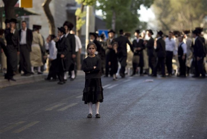
An Ultra-Orthodox girl stands in the street during a protest by hundreds of ultra-Orthodox Jews against the opening of a road on the sabbath in Jerusalem July 16, 2011. Israeli media reports said Saturday's protest marked the anniversary of the opening of a public parking lot over the objections of religious politicians and was also called to demand a main road running by their neighborhood be shut on the sabbath. REUTERS/Darren Whiteside
Authors Note and Personal Opinion:- (Not necessarily the opinion of the Publisher of the Website, although 99% of the time these points of view are identical, at least on a good day :-) It's really hard to know what to make of this whole thing. I suppose from a very photojournalistic point of view I believe the expressions on the children's faces tell a lot.
If you got to the website Vosizneias.com which is yiddish for What's News? Other than seeing there are many advertisers using the old style of "in your face" of the ads having movement or blinking on and off as an assault on your sense, you see many sorts of different pictures, that truly tell different stories.
Actually the more I think of it, and look at the photos, I really start to think to myself are the Ultra-Orthodox doing the right thing? I suppose initially as a Jew myself who recently (less than 5 years ago) starting living the orthodox lifestyle including keeping kosher (in and out of the house) separate dishes, I was thinking I should be on the same side as these folks, the "Ultra Orthodox that is".
Then I looked at the photos, the website itself really does not take a stand on the issue, it simply records facts. The photos record the facts as well, yet in my opinion the last three photos tell the story best.
I left out the middle one. The first photo here shows, the the two men sort of looking at each other as to say, "Maybe coming here was not such a good idea, and the boy at the right of the photo carrying a green bag, probably his snack, is may be thinking "Wow, this is cool" which might really be the age appropriate thing for the boy to think. Especially when one considers that the culture that the people shown here is generally sheltered and relatively isolated from worldly matters.
Actually if you give it even a little more thought, what these "ultra-orthodox believers" are doing is even worse, then perhaps the secular and non-religious Jews do by parking their cars in the parking lot. They have chosen "or were born" into this lifestyle. No one is coming after them and saying you must drive a car, or come to work on Shabbos. Now one is telling them, you must light fires, and turn light switches on and off. Do they have a point, a valid reason for their protest, perhaps? Are their methods just and proper to protest worldly affairs and to try to effect social change, on Shabbos? I for one, do not think so.
Finally it was the last photo in the Photo Story, that really made me think. I have included it as my last photos in this piece. The young girl, standing in the middle of the street, not quite understanding what she has witnessed. Her expression probably says more than I was able to with so much thought, and carefully composed words. Therefore I will not even try to describe what her expression reveals.
Protest, if you so choose, just not on Shabbos.
Stephen C. Sanders
aka- SandCloud.
PS: I guess I am not really surprised that I had a strong opinion on this matter after all. I first saw this in Jerusalem nearly two years. I guess the idea then was that the Chasidim were trying prevent cars from parking in the Garage by standing in front of them. This was done on shabbos too. Also if you go to the website, and see that the 1st comment also makes the same point that I make here, in far fewer words.
http://www.vosizneias.com/87601/2011/07/17/mea-shearim-800-orthodox-jews-protest-parking-lot-operating-on-sabbath

Ultra Orthodox Jewish men and boys run past Israeli policemen on horseback during a demonstration in Jerusalem, on 16 July 2011. Some 800 people rallied in the capital, clashing with police and trying to block a Jerusalem road to protest the opening of a parking lot on shabbat. EPA/OLIVER WEIKEN
An Ultra-Orthodox girl stands in the street during a protest by hundreds of ultra-Orthodox Jews against the opening of a road on the sabbath in Jerusalem July 16, 2011. Israeli media reports said Saturday's protest marked the anniversary of the opening of a public parking lot over the objections of religious politicians and was also called to demand a main road running by their neighborhood be shut on the sabbath. REUTERS/Darren Whiteside
Authors Note and Personal Opinion:- (Not necessarily the opinion of the Publisher of the Website, although 99% of the time these points of view are identical, at least on a good day :-) It's really hard to know what to make of this whole thing. I suppose from a very photojournalistic point of view I believe the expressions on the children's faces tell a lot.
If you got to the website Vosizneias.com which is yiddish for What's News? Other than seeing there are many advertisers using the old style of "in your face" of the ads having movement or blinking on and off as an assault on your sense, you see many sorts of different pictures, that truly tell different stories.
Actually the more I think of it, and look at the photos, I really start to think to myself are the Ultra-Orthodox doing the right thing? I suppose initially as a Jew myself who recently (less than 5 years ago) starting living the orthodox lifestyle including keeping kosher (in and out of the house) separate dishes, I was thinking I should be on the same side as these folks, the "Ultra Orthodox that is".
Then I looked at the photos, the website itself really does not take a stand on the issue, it simply records facts. The photos record the facts as well, yet in my opinion the last three photos tell the story best.
I left out the middle one. The first photo here shows, the the two men sort of looking at each other as to say, "Maybe coming here was not such a good idea, and the boy at the right of the photo carrying a green bag, probably his snack, is may be thinking "Wow, this is cool" which might really be the age appropriate thing for the boy to think. Especially when one considers that the culture that the people shown here is generally sheltered and relatively isolated from worldly matters.
Which is precisely my point. What is the lesson for the young children. Are they meaning or intending to teach their children, that its okay to violate the laws of the land in order to strictly adhere to Torah Observance, to their children. Or more importantly is it not obvious to most people with even an elementary and unsophisticated understanding of our Holy Torah, that by choosing the special and holy day of the Sabbath itself as the "proper and ideal time to conduct such protests" that they too are violating the sabbath every bit as much as those who park the car in the parking lot in Jerusalem.
Actually if you give it even a little more thought, what these "ultra-orthodox believers" are doing is even worse, then perhaps the secular and non-religious Jews do by parking their cars in the parking lot. They have chosen "or were born" into this lifestyle. No one is coming after them and saying you must drive a car, or come to work on Shabbos. Now one is telling them, you must light fires, and turn light switches on and off. Do they have a point, a valid reason for their protest, perhaps? Are their methods just and proper to protest worldly affairs and to try to effect social change, on Shabbos? I for one, do not think so.
I humbly conclude that even if you are strictly in accordance with all relevant Halacha (Jewish Law) "keeping Shabbos" yet if in your every deed and action, demonstrate that your are not honoring "sanctifying" or making Shabbos the special and holy say it is, then I am forced to conclude, that the people in these pictures, are not truly keeping Shabbos correctly.The next to last photo on the website, shows that, yes indeed, people are angry, there is a man down being helped up by his comrades, but yet they are talking, they are listening to each other, they are brothers, cousins, family, Jews with common ancestors.
Finally it was the last photo in the Photo Story, that really made me think. I have included it as my last photos in this piece. The young girl, standing in the middle of the street, not quite understanding what she has witnessed. Her expression probably says more than I was able to with so much thought, and carefully composed words. Therefore I will not even try to describe what her expression reveals.
Protest, if you so choose, just not on Shabbos.
Stephen C. Sanders
aka- SandCloud.
PS: I guess I am not really surprised that I had a strong opinion on this matter after all. I first saw this in Jerusalem nearly two years. I guess the idea then was that the Chasidim were trying prevent cars from parking in the Garage by standing in front of them. This was done on shabbos too. Also if you go to the website, and see that the 1st comment also makes the same point that I make here, in far fewer words.
http://www.vosizneias.com/87601/2011/07/17/mea-shearim-800-orthodox-jews-protest-parking-lot-operating-on-sabbath
Sunday, July 10, 2011
Schmidt's Israeli dream team - Globes
Schmidt's Israeli dream team - Globes: "Four out of the eight companies in which Eric Schmidt's Innovation Endeavors fund has invested are Israeli.
15 June 11 16:21, Roy Goldenberg
In March of this year, Google chairman and outgoing CEO Eric Schmidt celebrated his tenth year at the giant search engine company, and made way for Larry Page, one of the two founders of the largest Internet company in the world.
One of the goals of installing one of the founders in the company's hot seat is to take Google back to the way it ran early on, in the start-up days. While Google is being rejuvenated, Schmidt is regaining his appetite for entrepreneurship."
SVB Israel manager: Israeli tech companies shouldn't fear debt - Globes
SVB Israel manager: Israeli tech companies shouldn't fear debt - Globes: "David Cohen, partner and CFO at venture capital firm Gemini Israel Funds, is leaving his post after 13 years, and will shortly take up his new job as general manager for SVB Israel Advisors Ltd. (SVB Israel). Silicon Valley Bank (SVB) is a business unit of SVB Financial Group (Nasdaq: SIVB), founded 30 years ago with the aim of providing banking and financial services to technology and life sciences companies, venture capital firms, and the wine industry."
Subscribe to:
Comments (Atom)